

You can find on this page the Bulgaria road map to print and to download in PDF. The Bulgaria driving map presents the detailed road network, main highways and free motorways of Bulgaria in Eastern Europe.

The Bulgaria road map shows all roads network and main roads of Bulgaria. This road map of Bulgaria will allow you to preparing your routes and find your routes through the roads of Bulgaria in Eastern Europe. The Bulgaria roads map is downloadable in PDF, printable and free.
Long-term plans call for upgrading higher-quality roads and integrating the road system into the European grid. The focus is on improving road connectors with Turkey and Greece and domestic connections linking Sofia, Plovdiv, and Burgas. Bulgaria has delayed building some key highway connections since the 1990s, but European Union membership is a strong incentive for completion. Speed limits are 50 km/h (31 mph) in the cities/towns, 90 km/h (56 mph) out of town, and 130 km/h (80 mph) on the highways as its mentioned in Bulgaria roads map. For motorcycles, speed limits are 50 km/h in the cities/towns, 80 km/h out of town, and 100 km/h on the highways.
Traversing Bulgaria by road is still the best way to discover the country. To use Bulgaria road system beyond areas of settlement, one needs to purchase a vignette. The price for a period of one year is one of the highest within the EU, as it does not apply only to motorways, as is the case elsewhere. Bulgaria and its roads are part of a large international transit system, the so-called “Orient / Eastern Mediterranean” Trans-European Corridor, the shortest route connecting Western Europe to the Near and Middle East as its shown in Bulgaria roads map. On this route, the only non-motorway stretch was between Niš in Serbia and Sofia. The Bulgarian government has planned that in 2020 the country will have an operating road infrastructure: in the period 2014-2020, the Ministry of Regional Development will prepare projects for about €4 billion, and by 2013 funds provided for the operational programmes will amount to €2 billion.
The longest road in Bulgaria was the Road I-3, other roads, including roads without a hard surface, with a total length of 11,989 kilometers. Secondary or regional roads had a total length of about four thousand kilometers. However, motorways had the shortest length among the road network, with 757 kilometers in that year. Bulgarian roads with a pavement make up 98.4% of all the country roads, while 92.5% of them have an asphalt surface and 82.8% of them are able to carry 10tonnes/axle. The local/municipal and private roads have a total length of over 24,000km. In addition, the length of the street network in the urban areas is over 60,000km. The road network with highways and roads of Grades I, II, and III totalled 19,276km, and these are highways (331km), Grade I roads (2,961km), Grade II roads (4,012km), Grade III roads (11,730km) and road connections and nodes (242km) as you can see in Bulgaria roads map.

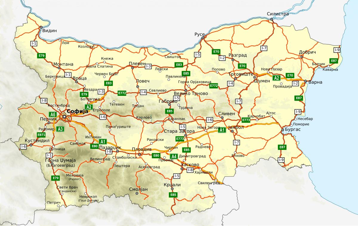
The Bulgaria highway map shows toll and free motorways of Bulgaria. This highways map of Bulgaria will allow you to prepare your routes on motorways of Bulgaria in Eastern Europe. The Bulgaria highway map is downloadable in PDF, printable and free.
Building new highways is one of the top goals of the 2009 elected government of Boyko Borisov, therefore new roads and highways are regularly opened for use. 324 kilometers of high-speed highways were in service in 2005 as its mentioned in Bulgaria highway map. As of 2011, 480 kilometers are in service. The National Strategy for Integrated Infrastructure Development calls for construction of 720 kilometers of new highways by 2015. A 114-kilometer link between eastern Bulgaria and the Turkish border is scheduled for completion in 2010. As of 2004, two international highways passed through Bulgaria, and a major highway ran from Sofia to the Black Sea coast. Proposed international corridors would pass from north to south, from Vidin to the border with Greece and from Ruse to the border with Greece, and west to east, from Serbia through Sofia to Burgas, Varna, and Edirne (Turkey). A new bridge link with Romania is scheduled for completion in 2011, relieving road and railroad congestion in that direction.
The highways in Bulgaria currently form a network with a length of less than 800 kilometers. So far, this is enough to drive from the capital in Sofia to the Black Sea. However, the Bulgarian government plans to build another 700 kilometers of expressways that will make it even easier to travel around the country. There are eight highways in Bulgaria. Four of them are fully completed: Trakija (360 km), Marica (117 km), Ljulin (19 km), and the northern tangent (16.5 km). The longest of them is to be the A2 motorway, which is to lead from the capital to Varna (433 km) as you can see in Bulgaria highway map. The Bulgarian government has announced that completing it is a top priority.
When it comes to marking highways in Bulgaria, they have the symbol of a capital A and the appropriate number. And so the following express routes can be distinguished: A1 called “Trakija”, it runs from the Serbian border to Burgas as its shown in Bulgaria highway map. A2 called “Hemus”, which is to run from Sofia to Varna. A3 called “Struma”, which is to connect Pernik with the Greek border. A4, called “Marcia”, leads from Privomaja to the Turkish border. A5 called “Czerno more”, which is to lead from Varna to Burgas. A6 called “Ljulin” runs from the Bulgarian capital to Pernik. A7 called “Kalotina”, which is to connect Sofia with the Serbian border. The last motorway is the planned route from Veliko Tarnovo to the Romanian border.