

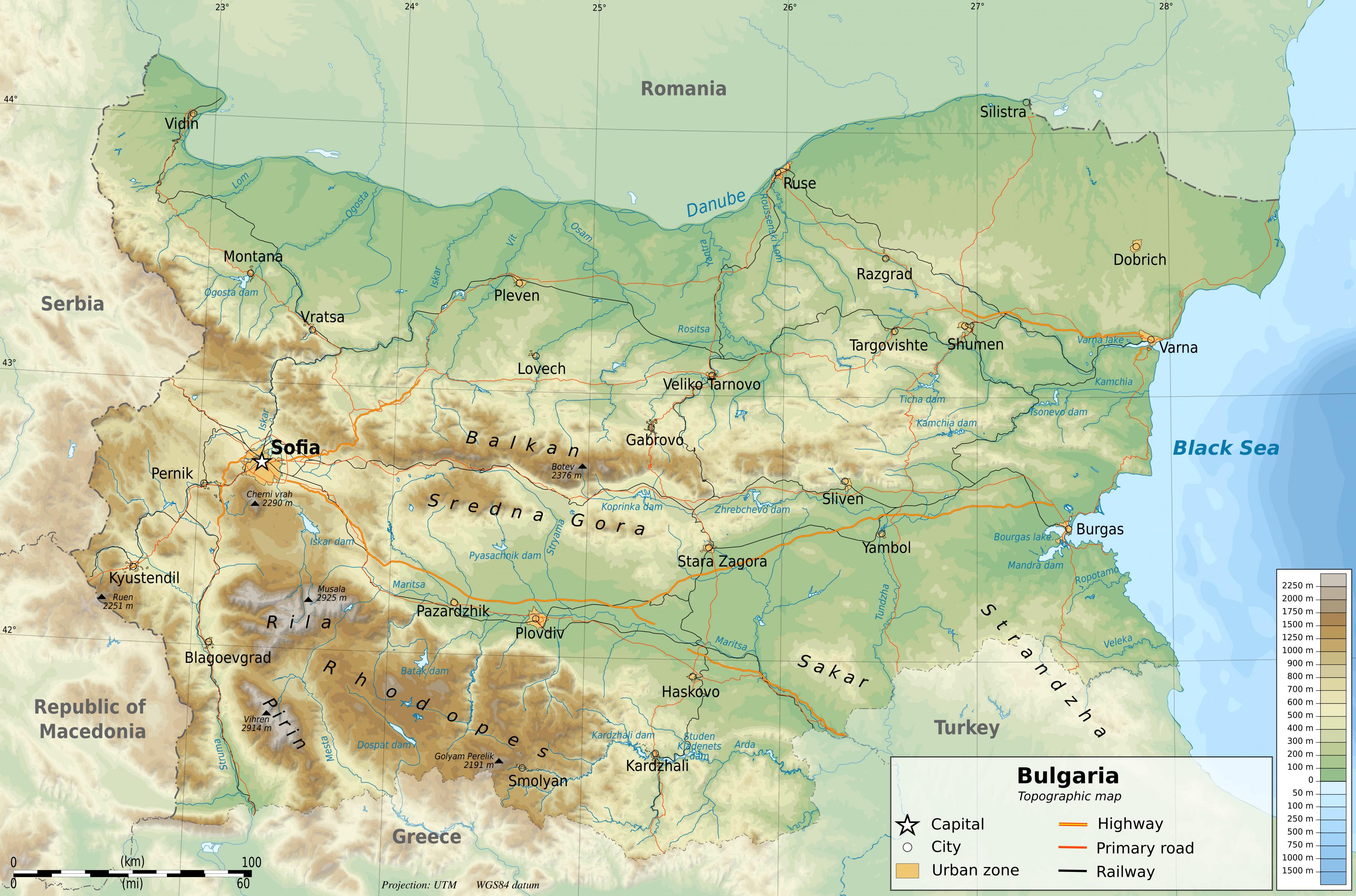
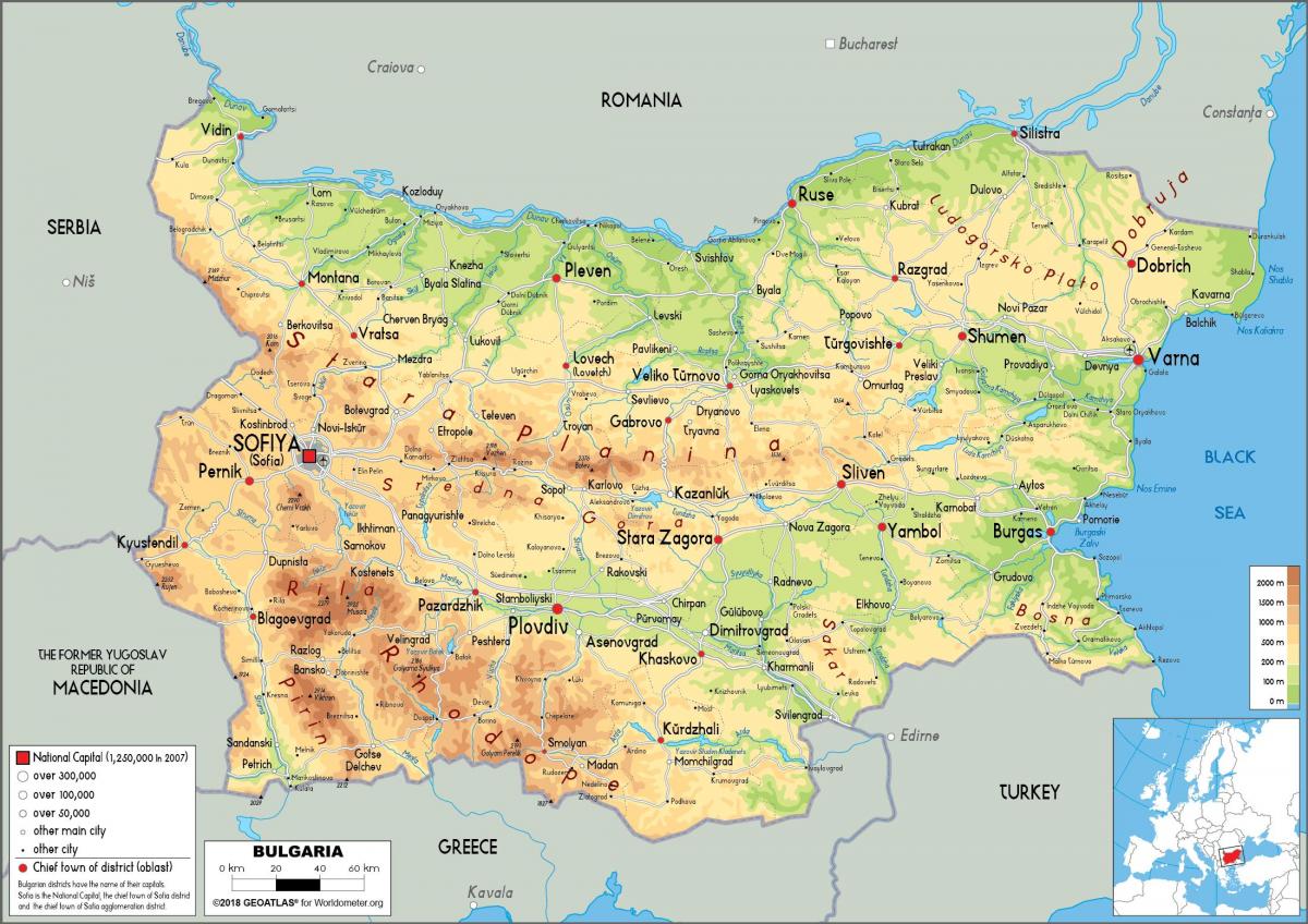
You can find on this page the Bulgaria geographical map to print and to download in PDF. The Bulgaria geographic map presents the topography, elevation, rivers, mountains, climate and physical features of Bulgaria in Eastern Europe.

The Bulgaria physical map shows landform and geography of Bulgaria. This geographical map of Bulgaria will allow you to discover physical features of Bulgaria in Eastern Europe. The Bulgaria physical map is downloadable in PDF, printable and free.
Bulgaria is situated on the west coast of the Black Sea, with Romania to the north, Greece and Turkey to the south, and Serbia and Macedonia to the west as you can see in Bulgaria physical map. Considering its small size, Bulgaria has a great variety of physical features. Even within small parts of the country, the land may be divided into plains, plateaus, hills, mountains, basins, gorges, and deep river valleys. The geographic center of Bulgaria is located in Uzana. Bulgaria features notable diversity with the landscape ranging from the Alpine snow-capped peaks in Rila, Pirin and the Balkan Mountains to the mild and sunny Black Sea coast; from the typically continental Danubian Plain (ancient Moesia) in the north to the strong Mediterranean climatic influence in the valleys of Macedonia and in the lowlands in the southernmost parts of Thrace.
Phytogeographically, Bulgaria straddles the Illyrian and Euxinian provinces of the Circumboreal region within the Boreal kingdom. According to the WWF and to the European Environment Agency's Digital Map of European Ecological Regions, the territory of Bulgaria subdivides into two main ecoregions as its shown in Bulgaria physical map: the Balkan mixed forests and Rhodope montane mixed forests. Small parts of four other ecoregions also occur on Bulgarian territory. The rivers of Bulgaria can be divided into two segments, one of the groups is feeding the Danube thus giving water to the Black Sea, these are the rivers north of the Balkan Mountains. The other group of rivers are joined by the Maritsa and Tundzha rivers in the east, and the Struma river on the west, which drive towards Greece and empty in the Aegean Sea.
The most prominent physical feature of Bulgaria are the two arc of mountains that chop the eastern and southern regions of the country as its mentioned in Bulgaria physical map. The Balkan Mountains is the northernmost of these, which also have an extension towards Serbia, while the Rhodope mountains reach into southern neighbour Greece. Rhodope is the highest of the two, Mount Musala almost breaks into the 3000-ers, with a height of 2925, making it the highest elevated extreme point of Bulgaria. The Balkan Mountains are considerably lower, with some of its summits concluding above 2200 meters. The maximal elevation of this range is 2376 by Peak Botev. Besides the white peaks of the high mountain chains, not far from these one can find sunny beaches on the Black Sea coast, lowlands near the Danube and Thrace in the southeast, which is also called Maritsa Basin after its main river. The Danubian Plain stretches on the whole northern border with Romania, and flat area is segmented by some plateaus and hilly sections.

Bulgaria topographic map shows the physical features of Bulgaria. This topographical map of Bulgaria will allow you to discover landforms and geographical of Bulgaria in Eastern Europe. The Bulgaria topographic map is downloadable in PDF, printable and free.
The relief of Bulgaria is varied. In the relatively small territory of the country there are extensive lowlands, plains, hills, low and high mountains, many valleys and deep gorges. The main characteristic of Bulgaria topography is alternating bands of high and low terrain that extend east to west across the country as you can see in Bulgaria topographic map. From north to south, those bands (called geomorphological regions) are the Danubian Plain, Stara Planina, the Transitional region and the Rilo-Rhodope Massif. The easternmost sections near the Black Sea are hilly, but they gradually gain height to the west until the westernmost part of the country is entirely high ground.
More than two-thirds of the country is plains, plateaus, or hilly land at an altitude less than 600 m. Plains (below 200 m) make up 31 % of the land, plateaus and hills (200 to 600 m) 41 %, low mountains (600 to 1,000 m) 10 %, medium-sized mountains (1,000 to 1,500 m) 10 %, and high mountains (over 1,500 m) 3 %. The average altitude in Bulgaria is 470 m as its shown in Bulgaria topographic map. The contemporary relief of the country is a result of continuous geological evolution. Due to that evolution there are magmatic, sedimentary and metamorphic rocks of different origin, age and composition. Their formation began more than 500 million years ago during the Precambrian and continues till now. The Bulgarian lands were often submerged by ancient seas and lakes, some land layers rose others sank. Volcanic eruptions were common both on land and in the water basins.
The Danubian Plain extends from the western borders to the Black Sea. It encompasses the area between the Danube River, which forms most of the country northern border, and Stara Planina to the south. It covers the Moesian plate as its mentioned in Bulgaria topographic map. As a result of the rock weathering processes the relief is uneaven with flat rising grounds along the valleys and plateaus to the east. The valleys of Vit and Yantra divide the Danubian plain into three parts - western, central and eastern. The altitude rises from west to east. To the north the plain has steep shores along the Danube or forms fertile alluvial plains (Vidinska, Chernopolska, Belenska, Pobrezhie, Aidemirska). Hilly heights and plateaus are typical for the topography of plain. Most of the heights and all plateaus are situated into the eastern parts.
The Bulgaria elevation map shows the different altitudes of Bulgaria. This altitude map of Bulgaria will allow you to know where are the highest and lowest regions of Bulgaria in Eastern Europe. The Bulgaria elevation map is downloadable in PDF, printable and free.
The terrain is mostly mountainous in Bulgaria with the north and southeast regions consisting of lowlands. Its major mountain range is the Balkan Mountains in the northcentral region. Whereas the Rhodope and Pirin Mountains lie in the south of Bulgaria. At 2,925 meters (9,598 ft) in height, Musala is the highest peak of Bulgaria as you can see in Bulgaria elevation map. This mountain peak translates to “Near God” from Arabic and is situated south of the capital city of Sofia. Other peaks of comparable height in the vicinity of Musala include Little Musala, standing at 2,902 m (9,521 ft), and Irechek, which is 2,852 m (9,357 ft). Bulgaria lowest elevation point is located on the coast, with its outlet on the Black Sea. The region stays steady at sea level, and stretches 354 km (220 mi), from the Romanian Black Sea Riviera to Turkey Marmara Region.
Musala (Bulgarian: Мусала; from the Ottoman Turkish Mus Allah, means "near Allah" and "place for pray") is the highest elevation peak in Bulgaria and the entire Balkan Peninsula, standing at 2,925 m (9,596 ft) as its shown in Bulgaria elevation map. The summit of the Rila mountain in southwestern Bulgaria, Musala is the highest peak between the Alps and the Caucasus and the highest in Eastern Europe bar the Caucasus. Musala is situated within the Rila National Park, which is noted for its rich flora, including species such as Macedonian Pine and Bulgarian Fir in the forests on its middle slopes, and fauna; it is one of the easiest places in Europe to see the wallcreeper. All major mountain ranges of Bulgaria can be seen from the top; these include Vitosha to the northwest, Sredna Gora towards the northeast, the Balkan Mountains along most of the northern horizon behind Vitosha and Sredna Gora, the Rhodope Mountains to the southeast, Pirin to the south, Osogovo and Ruy Mountain to the west, and of course Rila.
Bulgaria elevation map include the coordinates that are further north, south, east or west than any other location in Bulgaria; and the highest and the lowest elevations in the country. Also included in this list is the southern-most Bulgaria station in Antarctica. With the exception of Cape Shabla, the eastern-most location of Bulgaria, all other extreme points are uninhabited. Bulgaria northern-most point is where the Timok River flows into the Danube. The northern tip of Bulgaria is located in the Vidin Province, and neighbours the Mehedinţi County of Romania. The closest Bulgarian village to that area is Vrav. Bulgaria most southern point is in the Kardzhali Province Mount Veykata. At 1,463 metres (4,800 ft), Veykata is the highest Bulgarian peak of the Gyumyurdzhinski Snezhnik ridge in the Eastern Rhodope Mountains, and borders the East Macedonia and Thrace periphery of Greece. Bulgaria western-most point is in Mount Shulep Kamak of the Chudintsi Mountain, standing at 1,337 m (4,386 ft).
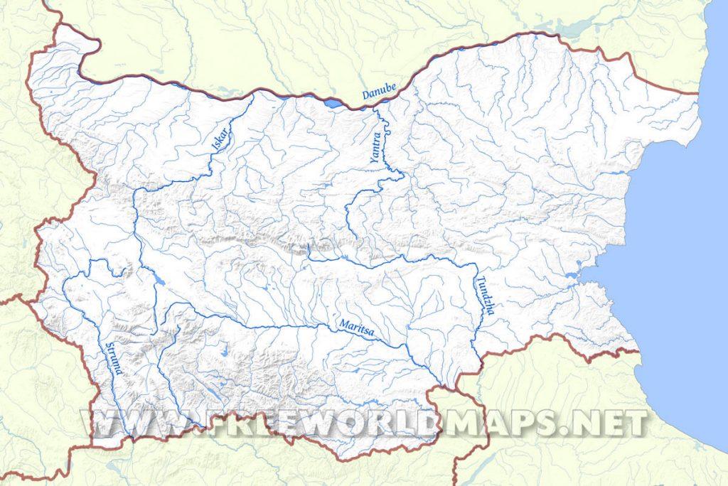
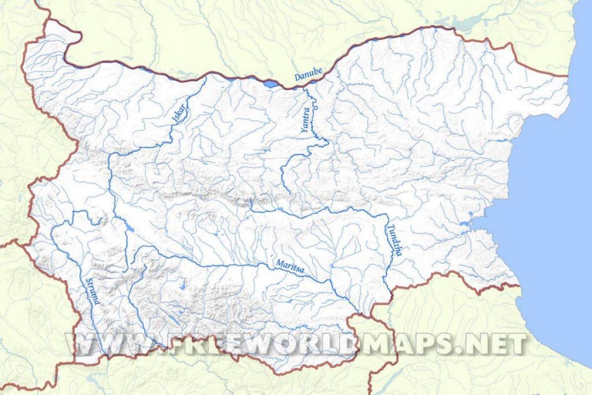
The rivers in Bulgaria map shows the principal rivers with their names of Bulgaria. The rivers map of Bulgaria will allow you to find the main rivers which flow in and through Bulgaria in Eastern Europe. The Bulgaria rivers map is downloadable in PDF, printable and free.
Bulgaria has a dense network of about 540 rivers, but with the notable exception of the Danube, most have short lengths and low water-levels as you can see in Bulgaria rivers map. Most rivers flow through mountainous areas; fewer in the Danubian Plain, Upper Thracian Plain and especially Dobrudzha. Two catchment basins exist: the Black Sea (57% of the territory and 42% of the rivers) and the Aegean Sea (43% of the territory and 58% of the rivers) basins. The longest river located solely in Bulgarian territory, the Iskar River, has a length of 368 km (229 mi). Other major rivers include the Struma and the Maritsa River in the south. The Balkan Mountains divide Bulgaria into two nearly equal drainage systems. The larger system drains northward to the Black Sea, mainly by way of the Danube River. This system includes the entire Danubian Plateau and a stretch of land running forty-eight to eighty kilometers inland from the coastline. The second system drains the Thracian Plain and most of the higher lands of the south and southwest to the Aegean Sea.
Only the Danube is navigable, many of the other rivers and streams in Bulgaria have a high potential for the production of hydroelectric power and are sources of irrigation water. Of the Danube Bulgarian tributaries, all but the Iskar River rise in the Balkan Mountains. The Iskur flows northward to the Danube from its origin in the Rila Mountains, passing through Sofia eastern suburbs and through a Balkan Mountain valley as its shown in Bulgaria rivers map. The Danube gets slightly more than 4 % of its total volume from its Bulgarian tributaries. As it flows along the northern border, the Danube averages 1.6 to 2.4 kilometers in width. The river highest water levels usually occur during June floods; it is frozen over an average of forty days per year.
Several major rivers flow directly to the Aegean Sea. Most of these streams fall swiftly from the mountains and have cut deep, scenic gorges. Maritsa with its tributaries is by far the largest draining all of the western Thracian Plain, all of the Sredna Gora, the southern slopes of the Balkan Mountains, and the northern slopes of the eastern Rhodopes as its mentioned in Bulgaria rivers map. After it leaves Bulgaria, the Maritsa forms most of the Greek-Turkish border. Struma and the Mesta (which separate the Pirin Mountains from the main Rhodopes ranges) are the next largest Bulgarian rivers flowing to the Aegean. Struma and Mesta reach the sea through Greece. The Rila and Pirin mountain ranges feature around 260 glacial lakes; the country also has several large lakes on the Black Sea coast and more than 2,200 dam lakes. Many mineral springs exist, located mainly in the south-western and central parts of the country along the faults between the mountains.
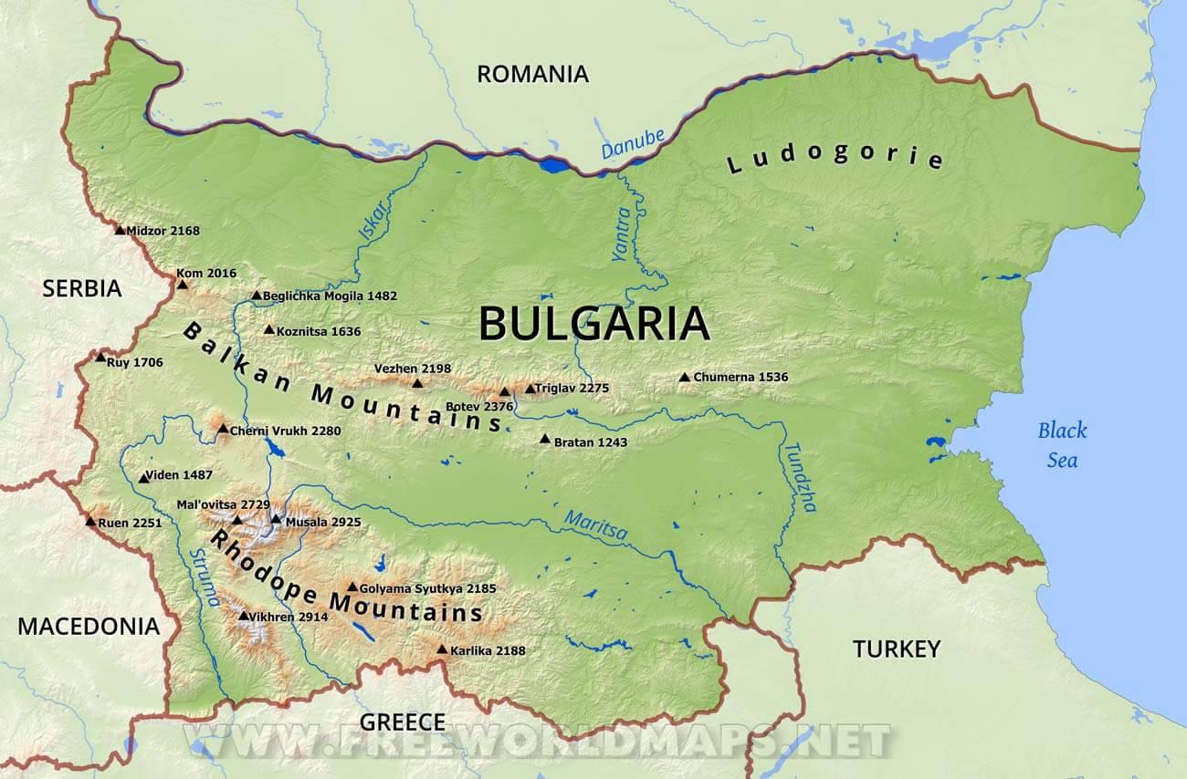
The mountains in Bulgaria map shows the principal mountains with their names in Bulgaria. The mountains map of Bulgaria will allow you to find the main mountains ranges and highest mountains of Bulgaria in Eastern Europe. The Bulgaria mountains map is downloadable in PDF, printable and free.
The Danubian plateau slopes gently from cliffs along the river, then it abuts into the low northern mountains of the Balkan range. The highest point is Tarnov Dyal (502 m) in the Shumen Plateau as you can see in Bulgaria mountains map. The southern edge of the Danubian Plain blends into the foothills of Stara Planina, sometimes thought of as the Bulgarian part of the Carpathian Mountains. The Carpathians resemble a reversed S as they run eastward from the Czech Republic and Slovakia across the northern portion of Romania, swinging southward to the middle of Romania and then running westward, where they are known as the Transylvanian Alps. The mountains turn eastward again at the Iron Gate, a gorge of the Danube River at the Romanian-Serbian border. At that point, they become Stara Planina of Bulgaria.
Stara Planina originates at the Timok Valley in Serbia and run southward towards the Sofia Basin in west central Bulgaria. From there they run east to the Black Sea. The Balkans are about 600 km long and 30 to 50 km wide as its shown in Bulgaria mountains map. They retain their height well into central Bulgaria, where Botev Peak, the highest point in the Balkan Mountains, rises to about 2,376 m. The range then continues at lower altitude to the cliffs of the Black Sea. The southern slopes of the Balkan Mountains and the Sredna Gora give way to the Thracian Plain and the Sofia Basin. Roughly triangular in shape, the Thracian Plain originates at a point east of the mountains near Sofia and broadens eastward to the Black Sea. It includes the Maritsa valley and the lowlands that extend from the river to the Black Sea. Like the Danubian Plateau, much of the Thracian Plain is somewhat hilly and not a true plain. Most of its terrain is moderate enough to cultivate.
Relatively high mountains occupy the area between the Thracian Plain and Sofia Basin and the Greek border to the south. The western parts consist of three ranges: the Vitosha Mountain south of Sofia, the Rila Mountains further south, and the Pirin Mountains in the southwestern corner of the country. They are the most outstanding topographic feature of Bulgaria and of the entire Balkan Peninsula as its mentioned in Bulgaria mountains map. The Rila range includes Mount Musala, whose 2,925-metre peak is the highest in any Balkan country. About a dozen other peaks in Rila are over 2,600 meters. The highest peaks are characterized by sparse bare rocks and remote lakes above the tree line. The lower peaks, however, are covered with alpine meadows that give the range an overall impression of green beauty. The Pirin range is characterized by rocky peaks and stony slopes. Its highest peak is Mount Vihren, at 2,915 meters the second-highest peak in Bulgaria. Further east are the extensive Rhodope Mountains.

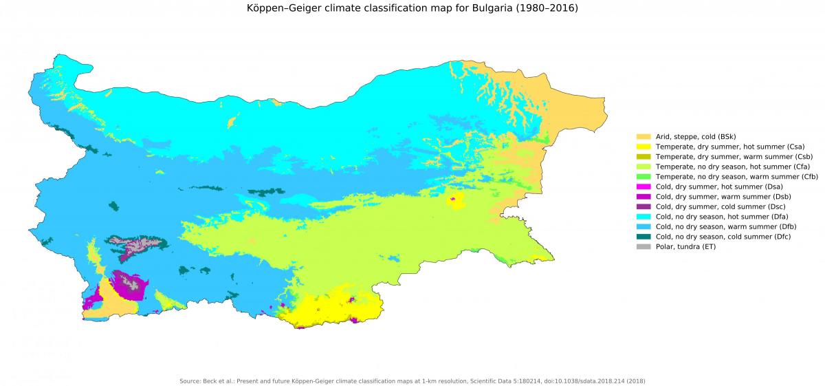
The Bulgaria climate map shows average temperature and climate zones of Bulgaria. This climate map of Bulgaria will allow you to know weather, average precipitation, average sunshine and different climates of Bulgaria in Eastern Europe. The Bulgaria climate map is downloadable in PDF, printable and free.
Considering its small area, Bulgaria has an unusually variable and complex climate. The country lies between the strongly contrasting continental and Mediterranean climatic zones. Bulgarian mountains and valleys act as barriers or channels for air masses, causing sharp contrasts in weather over relatively short distances. The continental zone is predominant, because continental air masses flow easily into the unobstructed Danubian Plain. The continental influence, stronger during the winter, produces abundant snowfalls; the Mediterranean influence increases during the second half of summer and produces hot and dry weather. The barrier effect of the Balkan Mountains is felt throughout the country: on the average, northern Bulgaria is about one degree cooler and receives about 192 millimetres (7.6 in) more rain than lowlands of southern Bulgaria as you can see in Bulgaria climate map.
Because the Black Sea is too small to be a primary influence over much of Bulgaria weather, it only affects the immediate area along its coastline. The Balkan Mountains are the northern boundary of the area in which continental air masses circulate freely as its shown in Bulgaria climate map. The Rhodope Mountains mark the northern limits of domination by Mediterranean weather systems. The area between, which includes the Northern Thracian Plain, is influenced by a combination of the two systems, with the continental predominating. This combination produces a plains climate resembling that of the Corn Belt in the United States, with long summers and high humidity. The climate in this region is generally more severe than that of other parts of Europe in the same latitude. Because it is a transitional area, average temperatures and precipitation are erratic and may vary widely from year to year.
Average precipitation in Bulgaria is about 630 millimetres (24.8 in) per year. Dobrudja in the northeast, the Black Sea coastal area, and small part of the Northern Thracian Plain usually receive less than 500 millimetres. The remainder of the Northern Thracian Plain and the Danubian Plateau get less than the country average; the Northern Thracian Plain is often subject to summer droughts. Higher elevations, which receive the most rainfall in the country, may average over 2,540 millimetres (100 in) per year. Temperatures in Sofia average −3 °C (26.6 °F) in January and about 28 °C (82.4 °F) in August as its mentioned in Bulgaria climate map. The city rainfall is near the country average, and the overall climate is pleasant. In summer, temperatures in the southest Bulgaria often exceed 40 °C (104 °F) but remain cooler by the coast. The town of Sadovo, near Plovdiv, has recorded the highest known temperature: 45.2 °C (113.4 °F). The recorded absolute minimum temperature of −39.3 °C (−38.7 °F) occurred west of Sofia, near the town of Trun. The usual temperature around the Stara Planina region averages 10 °C (50 °F) to 15 °C (59 °F).